
Community Life
For residents we hope that this website provides a comprehensive and accessible catalogue of the information you need about the area and its community.
We have provided special pages to direct people visiting or working here to sections that may be of particular interest to them, but we believe the majority of the information on the website is useful for residents so the main navigation bar (always visible wherever you are on the site) is for you.
Please have a good look around under each of the main menu items: like the village and its surroundings, there may be more to it than initially meets the eye.
The remainder of this page is given over to information and links about ongoing community issues, where possible providing the opportunity for residents to have their say.
Ongoing Community Issues (Have your say)
Follow the links below to get the latest information or register your opinion about issues of general concern.
STORRINGTON TRAFFIC

In November 2023, the Storrington & Washington District Cllrs Claudia Fisher, Joan Grech, and Emma Beard convened a public meeting at the Chanctonbury Leisure Centre to address growing concerns about traffic congestion and speeding in the area. The meeting, attended by over 80 residents, led to the formation of the Storrington Traffic Group (STG).
The STG, a joint initiative involving the Parish Council, local residents facilitated by the District Councillors, Storrington Speedwatch and other local stakeholders, aims to represent the interests of the community and advocate for safer roads. With over 500,000 vehicles passing through Storrington, Sullington, and Cootham each month, the wellbeing of residents is being significantly impacted. Alarmingly, over 40% of vehicles on the main roads in and out of Storrington are exceeding the speed limit, with more than 6,000 speeding vehicles per day in this small area. This excessive traffic not only poses a serious risk to pedestrians and cyclists but also contributes to air pollution levels that far exceed World Health Organization (WHO) recommendations.
The STG’s efforts are being supported by Horsham Community Police Inspector Neil Durkan and Sussex Police & Crime Commissioner Katy Bourne, who has pledged £5,000 to fund two new Speed Indicator Signs (SIDs).
Petition for a 20mph for Storrington, Sullington & Cootham
The pro-20mph petition signatures are evidence of support for a Community Highways Scheme to introduce 20mph across the village. The petition is now closed. The final number of signatures gathered was 4,251.
Details of the background to this petition are published 20mph Speed Limit
Speed Indicator Devices
Speed Indicator Devices (SIDs) record statistics (vehicle numbers, speed, date, time of day). The purchase of another two SIDs has been approved by the Parish Council. The Parish Council priority locations for these SIDs are Amberley Road, Fryern Road and/or Water Lane, but other locations are also under review.
Traffic Regulation Order (TRO) for speed limit reduction on B2139
The TRO to reduce the speed limit on the B2129 (Amberley Road) had failed. WSCC Highways said that the two road accidents on Mother’s Day (30th March 2025) had not been speed related. They suggested that instead of a reduction from 60mph (national speed limit) to 40mph a reduction from 60mph to 50mph should be requested.
Future Progress
The STG group is currently dormant but you can still contact them via the email StorringtonTrafficGroup@gmail.com.
The Parish Council Traffic & Transport Committee is progressing a range of initiatives and will share more information as the projects take shape. The Parish Council can be contacted at office@storrington-pc.gov.uk or 01903 746547.
![]()
NEIGHBOURHOOD PLAN 2019-2031
A Neighbourhood Plan is a way of helping local communities to influence the planning of the area in which they live and work.
The Storrington, Sullington and Washington Neighbourhood Plan process was launched at a public meeting on 21 November 2013 and has been developed over the last few years. A referendum was held on 18th July 2019. The question voted on was:
“Do you want Horsham District Council and South Downs National Park Authority to use the Neighbourhood Plan for Storrington and Sullington Parish, and Washington Parish to help it decide planning applications in the neighbourhood area?”
On 18 July 2019, the Storrington & Sullington and Washington Neighbourhood Development Plan to 2031 successfully passed Referendum with 86% of the votes cast agreeing that the Storrington & Sullington and Washington Neighbourhood Development Plan be used by Horsham District Council and South Downs National Park Authority to help in the determination of planning applications in the Parishes of Storrington & Sullington and Washington (turnout at the Referendum was 19.13%).
It was therefore confirmed, that the Storrington & Sullington and Washington Parish Neighbourhood Development Plan to 2031, (incorporating Examiner’s modifications as set out in the Horsham District Council Decision Statement), complies with the legal requirements and basic conditions set out in the Localism Act 2011. As a result of the Council resolution of 4 September 2019, the Storrington & Sullington and Washington Parish Neighbourhood Development Plan 2031 has been ‘made’ with effect 5 September 2019.
Horsham District Council Neighbourhood Plan adoption statement.
The final plan is published on the Storrington & Sullington Parish Council website: Neighbourhood Plan (June 2019)
HORSHAM DISTRICT LOCAL PLAN 2023 – 2040

Horsham District Council has reviewed the Local Plan which will guide future developments in the Horsham District until 2040.
The Government requires all local planning authorities to build a significant number of new homes in the coming years. This will present considerable challenges for the Council. A Horsham District Local Plan will seek to show how the District will deliver new homes while seeking to minimise the effect on the environment and landscape. The Plan will also support the delivery of community infrastructure, transport links and opportunities for local jobs.
On 11 December 2023 Horsham District Council approved the publication of the Horsham District Local Plan 2023 – 2040 Regulation 19 document for a six week period of representation from Friday 19 January 2024 to Friday 1 March 2024.
The full Draft Local Plan is on the Council’s website at Horsham District Local Plan
Copies of the Draft Local Plan can also be viewed at the Council’s offices, Parkside, Chart Way, Horsham, RH12 1RL and in all District libraries during normal opening hours.
The consultation period ends at 5pm on the 1st March and objections / comments can be made through the HDC website or in writing. If your comments are made via the web they will be sent to the Planning Inspectorate as part of their review, if you send them by post it is not clear whether HDC have to send in your actual letter or can make a précis of it.
The role of the Planning Inspectorate is to assess whether the plan is ‘sound’ in relation to a string of policies. To be ‘sound’ it has to be:
- ‘Justified’ meaning it is an appropriate strategy taking into account the reasonable alternatives, based on proportionate evidence.
- ‘Effective’ meaning that based on what has been submitted, the plan is deliverable over the plan period, and any key matters have been dealt with, rather than deferred in such a way as to limit the deliverability of the plan.
- ‘Consistent with national policy’ in relation to sustainable development according to the various policies in the framework and other national planning policies.
The government has set annual housing targets for each local authority based on what it judges their contribution to the overall total should be.
See this BBC article for details Councils ordered to increase home building
A number of local groups throughout the District are advising their members as to where they believe the District Local Plan fails on these 3 counts from their perspective. For example, in the Storrington & Sullington Parish there is a group called Stop Storrington Sprawl, which focuses on land north of Melton Drive/Downsview designated as part of the Green Gap between Storrington and West Chiltington in the Neighbourhood Plan, but accepted for potential housing development in the District Local Plan.
Stop Storrington Sprawl
Most of these local groups are not opposed to building where the community has been listened to and there is a delivered community benefit in relation to social housing, a high bio-diversity gain, future proofing homes for climate change and a true delivery of the required infrastructure (e.g. GP surgeries and other medical services, dentists, schools, roads, power lines, broadband, sewerage, public transport etc.). In general, these considerations have been expressed in Neighbourhood Plans supported by referendum votes and “made” by Horsham District Council.
Once a Neighbourhood Plan is “made”, it is accepted by the District Council as part of its Development Plan and should be used in the determination of planning applications within the Neighbourhood Plan designated area. This is the status of the Storrington, Sullington and Washington Neighbourhood Plan 2018-2031. Elements of the draft District Local Plan appear to be in conflict with several Neighbourhood Plans, including the one for Storrington, Sullington and Washington.
If you want to understand more, please come to the Parish Council Planning & Development Committee meeting at 7pm, 15 February, submit your opinion to Horsham District Council and keep an eye out for further meetings.
AIR QUALITY
As you may be aware Horsham District Council has been monitoring air quality in the centre of Storrington for some time. An Air Quality Management Area (AQMA) was declared by Horsham District Council in December 2010. With an Air Quality Action Plan (AQAP) subsequently developed in 2012, in partnership with West Sussex County Council and the Parish Council. The AQAP details the measures proposed to reduce pollution levels to within European and UK Government objective levels in the centre of the village.
See the latest:
Storrington Air Quality Action Plan Sussex-Air Storrington Air Quality Monitoring Highways England A27 Arundel BypassRAMPION 2 WIND FARM
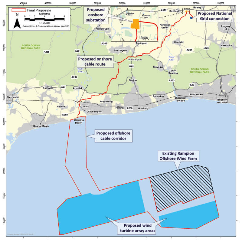
The DCO application for the Rampion 2 Offshore Wind Farm has been accepted for examination by the Planning Inspectorate. The application is for an offshore wind farm with an area up to approximately 196km2 comprising up to 90 wind turbines and associated foundations, inter-array cables connecting the turbines to up to three offshore substations, and export cables taking the power to shore at Climping.
The application includes all the onshore electrical infrastructure required to transmit the power to the final connection into the national electricity network at Bolney in Mid Sussex. This includes an underground onshore cable route approximately 38.8km long from the landfall at Climping to a new onshore substation at Oakendene, 2km east of Cowfold. The map, to be found at the bottom of the latest newsletter, shows the cable route crossing the A24 just south of the Washington roundabout.
Rampion 2 NewsletterRIVERS AND SEAS WATCH
![]()
Rivers and Seas Watch is Southern Waters online service which provides near real-time information about storm overflow releases across the region. When a potential storm overflow release is identified by our monitoring equipment (EDMs), a release event is created and shown on Rivers and Seas Watch. Every storm overflow outfall in our region is shown.
Rivers and Seas WatchTHE LANDLINE TELEPHONE CHANGE OVER
Landlines in the UK are going digital with the retirement of the copper phone network. The existing analogue technology (the PSTN – Public Switched Telephone Network) which has supported phone and broadband services for decades is being retired and switched off.
Horsham District Council: Council’s Community Link service is ready for the digital switchover. HDC Community Link Service
BT: has indicated that the change over will take place in Winter 2025 for the South East.
Landlines In The UK Are Going Digital
WHICH?: Five things you need to know about the landline switchover. What You Need To Know About The Landline Switchover
AGE UK: Are landlines being phased out?
Landlines aren’t being phased out, but the UK’s telephone network is being upgraded, so landline services are changing. For most, switching over will be straightforward, but some people may need new equipment or support to make the changes.
Are Landlines Being Phased Out?