Outdoor Activities
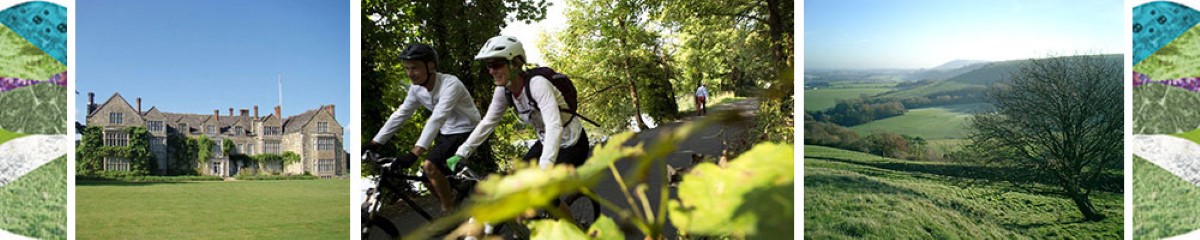
Storrington is a great centre for outdoor activities. Located at the mid-point of the South Downs Way, the Downs can easily be explored on foot, by bike, by horse or from the air by glider (flying the South Downs Ridge).
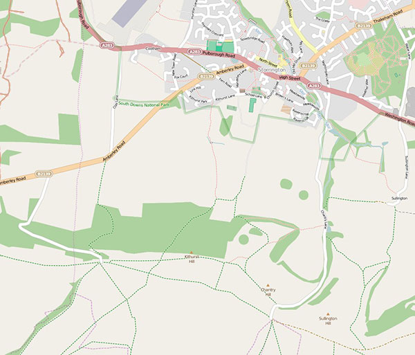
Although the paths to the Downs from the town are quite steep (roughly a 45 minute walk), there are also two car parks close by on the Downs that make the views easily accessible. From Kithurst Hill, right above the town, you can see: the sea along the Sussex coast, the Isle of Wight, Black Down (the highest hill in Sussex), the North Downs in Surrey and Kent and everything in between.
THE ROUTES TO THE DOWNS

Click anywhere on this map to go to OpenStreetMap showing a contoured map with the paths from Storrington to the South Downs National Park and to the South Downs Way.
The paths to the Downs are quite steep. The South Downs Way is about 1.5 miles (2.5 kilometres) by footpath and 150 metres in elevation above the centre of Storrington and it takes about 45 minutes by foot. There is no parking up Greyfriars Lane, but there is a limited amount of temporary car parking by the South Downs Way at the top of Chantry Lane (Chantry Hill) and at the top of the unmarked road off Amberley Road (towards Kithurst Hill).
OpenStreetMap has a number of useful features for walkers and cyclists including a direction finder which recognises the paths.
LOCAL WALKS
Here are four local walks prepared for you by the Storrington & Sullington Community Partnership. This leaflet contains a brief description and map of each walk.
For a full description, click on the name of the walk below to open a PDF file. You are welcome to download and print out all of the information.
FIND WALKS NEARBY – CLICK ON THE ICONS
See Horsham District’s history first-hand with these self-guided heritage trails exploring the towns, villages and countryside. Each trail is dedicated to a different area of the District and includes sites of special interest and stories from all eras of the area’s past. There are PDF leaflets to download.
There are several trails covering areas local to Storrington recorded by a local team organised by Storrington Community Partnership.
The trails project is supported by Horsham District Community Partnerships Forum and local history societies with National Lottery Heritage Funding.
The Fancy Free Walks website is a guide for people who love to walk, to observe and enjoy our incredible countryside (and townscapes too) at a leisurely speed, and who like to read a little of the story behind the places they visit. Distances vary from a soothing 1½ km (1 mile) to a bone-shattering 42 km (26 miles).
The routes are described in fine detail using both text and maps. If you like careful and precise directions all along the way, these walks are designed specially for you!
West Sussex County Council has a range of information about outdoor activities. In particular, there is a downloadable leaflet describing trails suitable for all including wheelchair and pushchair users, families and less mobile people.
Walk between any town, city and national landscape in Britain. 10,000 A-to-B walking and wheeling routes, mapped and checked by the Slow Ways community.
Connect Storrington with Slow Ways. 6 more walks and reviews are needed to fully connect Storrington to the verified network.
ORGANISED ACTIVITIES
Notes
Welcome to Arun-Adur Ramblers in West Sussex, part of the Ramblers Association.
Our group is centred around Worthing, close to the South Downs National Park and our walks range from Chichester to Eastbourne, with many local ones.
We provide regular walks through local countryside and we are always pleased to see new faces. To try our walks just turn up !
We arrange social events and some members monitor footpaths that provide access to the local countryside for all walkers.
Coombes Farm Experience
Coombes Farm ExperienceSussex Working Farm ExperienceCoombes Farm Church Farm Coombes Lancing, West Sussex, BN15 0RS work
Phone: 01273 452028work
Email: berty@coombes.co.ukINTERNET
Website: coombes.co.uk
Horsham District Mystery Trails
Horsham District Mystery TrailsFREE outdoor mystery trail games in Storrington and across the Horsham District. See notes below…Storrington Library Ryecroft Lane Storrington, West Sussex, RH20 4PA work
Website: www.whistlestoparts.org/mysterytrails
Notes
HOW TO PLAY
Visit Storrington Library*, collect your Mystery Trail (download) and look at the Curator’s workspace to start the quest
Explore the town and solve the puzzles in any order – It’s not timed unless you want it to be!
Need an extra clue? Hints are by the space for your answers
Once you’ve solved all the clues, return to the Curator’s workspace to uncover the final answer.
You’ll also find a message waiting for you… Solve the numerical puzzle to discover the phone number
Enter the library* and whisper the name of the seed you have found to a member of staff, and they will reward you with a sticker to be placed on the back of your Curators’ Alliance notebook
Complete all seven town trails and show your stickers at any collection point to receive your eighth bonus sticker
Once you have all eight stickers reassemble the letters on each to spell the secret word that unlocks the final chapter of Answare and the Curators’ Alliance Cabinet of Cures.
*If the library is closed, check the notice in the window of the Curator’s workspace for an alternative collection point
Knepp Castle Estate
Knepp Castle EstateRewilding pioneersNew Barn Farm Swallows Lane Dial Post, West Sussex, RH13 8NQ work
Phone: 01403 713230 Camping, Glamping Safariswork
Phone: 01403 470690 Wilding Kitchenwork
Email: safaris@knepp.co.ukINTERNET
Email: wildingkitchen@knepp.co.ukINTERNET
Website: knepp.co.uk
National Garden Scheme
National Garden Scheme3,500 breathtaking private gardens opening for charity – find yourself a fantastic day out.
Phone: 01483 211535work
Email: louise@ngs.org.ukINTERNET
Website: ngs.org.uk
Pied A Terre Adventures
Pied A Terre AdventuresYour gateway to the outdoors: unique and inspiring walking experiences.Summit House 12 Morris Drive Billingshurst, West Sussex, RH14 9SF work
Phone: +44 (0)1403 788994work
Email: mytime@patadventures.comINTERNET
Website: www.patadventures.com
Notes
Pied A Terre Adventures is a family run company based in West Sussex offering unique and inspiring walking and outdoor experiences throughout the UK.
Pulborough Paddles Limited
Pulborough Paddles LimitedCanoe, Kayak and Paddleboard Rentals in SussexToll House Stopham Road Pulborough, West Sussex, RH20 1DS United Kingdomwork
Phone: 07538211071work
Email: info@pulboroughpaddles.co.ukINTERNET
Website: www.pulboroughpaddles.co.uk
Notes
Canoe, Kayak & Paddleboard Hire – Get away from the masses and join our family run business on the banks of the river Arun. Take your time and relax at our stunning launch site. Explore the one of the most beautiful and calm sections of the Arun river. We have free parking and onsite refreshments, everything for a great day out by the river.
Southdown Gliding Club
Southdown Gliding ClubParham Airfield Pulborough Road Cootham Storrington, West Sussex, RH20 4HP home
Phone: 01903 742137 (Office – Mon-Fri 9:30 – 12:30)work
Phone: 01903 746706 (Clubhouse – Weds / Sat / Sun / Other flying days)work
Email: office@southdowngliding.co.ukINTERNET
Website: www.southdowngliding.co.uk
Notes
Southdown Gun Club is placed in the heart of Sussex, located just North of Worthing, near Findon.
Southdown Gun Club is a firm favorite with clay pigeon shooters of all abilities. For the experienced shooter there is skeet, DTL, ABT, Compak and our famous English sporting practice layout. With regular registered competitions for all disciplines including English sporting, FITASC & Sportrap, offering cash prizes in all classes.
If you are new to shooting we have starter stands and qualified instructors who will soon have you confidently breaking clays. This is coupled with our activity centre where we also offer Corporate days and clay shooting experiences for stag, hen & birthday parties.
We are the best clay shooting ground in the South, so come and see us soon, we’ll be happy to show you around.
Notes
Regularly listed in the top 20 shoots in the UK, Springhead produces some of the most outstanding driven Pheasants and Partridges in the county.
The shoot consists of part of the north facing escarpment of the South Downs between Storrington and Amberley as well as some flatter ground to the north. Most days start with a drive on the lower ground to allow the Guns a chance to get their eye in before moving onto the hill and some seriously testing birds. Drives such as Gullies, Kithurst Hill and Targets are some of the finest in the country. Having seen teams fail to reach their anticipated bag with ratios of up to 17 to 1 in the past the Estate now lets each day on the basis that the team will fire a minimum number of shots during the day (there is no maximum) and the bag achieved is purely down to the skill of those shooting.
Notes
The Storrington Tennis Club, founded in 1938, is a friendly Club which warmly welcomes new members. It caters for all standards of play, from beginners to team players, from the young to the more mature. It is situated on the edge of Storrington in an idyllic location just at the foot of the South Downs. The Club runs a number of teams in the senior and junior section that compete against various clubs in the county, both during the summer and winter months.
The club offers outstanding tennis facilities. We are a private members Club with a thriving membership of 500, made up of 290 seniors, 130 juniors and 80 mini tennis members and it’s expanding!!
Nine Courts in Total (seven are floodlit)
Five Astroturf Courts
Two Artificial Clay
One Macadam Hard Court
One Mini Court
Clubhouse (free WIFI)
Showers
Catering
On-line court booking
The Old Workshop at Sullington Manor Farm
The Old Workshop at Sullington Manor FarmSee our website, Facebook or Instagram for latest opening times.Sullington Manor Farm Sullington Lane Storrington, West Sussex, RH20 4AE work
Phone: 01903 745754work
Email: info@sullingtonmanorfarm.co.ukINTERNET
Website: www.sullingtonmanorfarm.co.uk/
Notes
An exhibition, loos and a café for all the walkers, cyclists and holiday makers who use Sullington as their gateway to the Downs.
See Sullington Manor Farm website for latest opening times.